|
fx - EXTENDED MAP SETTINGS |

|

Version 2.5.84, 07.12.2017 |
fx - EXTENDED MAP SETTINGS
|
fx - EXTENDED MAP SETTINGS |
|
Version 2.5.84, 07.12.2017 |
wrapDateLine, showScaleLine and unitsFactor Tileserver Provider - GoogleMaps, BingMaps, MapBox, HERE Tileserver MapBoundaries |
 click to expand |
The values for nearly all features may be entered as calculated formulas or variables. |
For detailed information about the notation in expression editors go to chapter The fx‑editor. |
EXTENDED MAP SETTINGS |
|||
|---|---|---|---|
SETTING / VALUES |
EXPLANATION |
||
|
|||
|
true map will be wrapped (default) false map won't be wrapped |
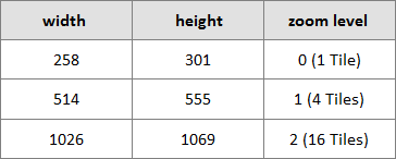
"Wraps" the background map (like GoogleMaps or BingMaps) along the date line - that means the map will be repeated east- and westwards so the map can be panned endlessly. Even without a background map, every layer (with Markers, Lines or Polygons on it) will be repeated too, but the items are shown only once at a time, depending on which map/"site" the bigger part of each item is positioned. This feature is very helpful for orientation, when you work in a area near the date line. For example to switch from Canada to Japan you only have to pan slightly to the left instead of "crossing" whole Europe until you get to the "other end" on the right. The following applies only if a background map or tiles are used: The following table shows the optimal object measures where the entire background map can be displayed and no gray edges (above and below) are visible: |
The green line in the screenshots below symbolizes the date line.
wrapDateLine = true  click to expand
wrapDateLine = false Beyond the map only the white background is shown.  click to expand |
|
|
 click to expand |
||
Reason for these measures is the default image size of the Tiles, background maps exist of - see screenshot above. They are always 256x256 Pixel in size. If you add the border of the object and the height of the menu bar (43px) you get the numbers in the table. Google Maps has the special feature to wrap the map, even if wrapDateLine is false, as a kind of buffer. However the extensions aren't dynamic and no item would be repeated as well as the map can be panned sidewards only to a certain extent. |
|||
showScaleLine true scale is visible false scale is not visible (default) |
Enabling this feature displays a scale in the bottom left corner, always showing kilometers and miles. |
||
|
number unit for distances, number from 0 to 3 (default is 1) |
Defines the measure unit used in the NPGeoMap object. 0 = meters Units for all further calculated distance and area information in NPGeoMap can be generally configured in the fx‑EXTENDED SETTINGS. |
||
|
|||
This section is for setting your keys and IDs for the respective tile server provider to display Background Maps. Please note that the usage of external Tile Servers like Google Maps is always bound to their respective Terms and Conditions - make sure that the use is permitted in your environment. |
 click to expand |
||
GoogleMaps |
Tile Server Provider of GoogleMaps is Google. |
||
api version used API version of GoogleMaps |
Allows to use a specific API version of GoogleMaps. |
||
freepublicaccessibility |
Due to a change of the Google Maps APIs on 22nd of June 2016 (see official Google announcement), this feature is no longer supported. |
||
key your GoogleMaps Key Your GoogleMaps key. |
GoogleMaps can only be used with a valid API key - see tutorial "How to create a GoogleMaps API key". Further information about GoogleMaps key: |
||
channel your GoogleMaps channel |
Used to provide additional report details within Google Maps API Console by grouping different channels in your reports separately. |
||
client your GoogleMaps Client ID |
Further information about GoogelMaps Client ID: |
||
BingMaps |
Tile server provider of BingMaps is Microsoft. |
||
key your BingMaps Key see further details on the right |
For detailed information about accessibility and the terms of use for BingMaps key please go to: http://www.microsoft.com/maps/create-a-bing-maps-key.aspx This Backgroundmap can't be displayed in NPGeoMap without a valid key. |
||
MapBox |
MapBox is a platform that offers to create and design individual maps, such as defining own colors for streets or terrain. |
||
accesstoken your Mapbox access token see further details on the right |
In order to use Mapbox you need set here a valid Mapbox accesstoken. Have a quick look on our Tutorial How to get a Mapbox Access Token..
|
||
mapid your MapBox ID see further details on the right |
You can use predefined maps from Mapbox like: mapbox.light, mapbox.dark and more: mapbox.com/api-documentation/#maps |
 click to expand  click to expand |
|
styleurl your style URL see further details on the right |
Set here custom created styles, and use the format: mapbox://styles/xxx/aasddad8004asdhzggaad4 |
||
The Tile Server Provider HERE (former Nokia) supports many map features - see below - and provides the usage of Isochrones in NPGeoMap. |
|||
appcode your HERE code see further details on the right appid your HERE ID see further details on the right |
For detailed information about accessibility, terms of use and further features for HERE please go to: This Backgroundmap can't be displayed in NPGeoMap without valid appcode and appid. |
||
pointsofinterest publictransport truckrestrictions nightmode greymode true feature enabled false feature disabled |
These features affect the appearance of the HERE Backgroundmap dislpayed in NPGeoMap. pointsofinterest publictransport truckrestrictions nightmode greymode |
 click to expand |
|
|
|||
In this section you can configure local or external tile server or embed local tiles. |
|||
urls |
|||
local true lokal tiles (default) false tiles come from a server |
Information for the program where to look for the image files / tiles - either the files are stored locally or provided by a tile server. If the files are locally stored, they have to be located within the NPGeoMap extension directory. The advantage of local tiles is to use a background map without the need of a working internet connection. |
||
url directory path tile location, local and server |
Fill in the location where your tiles are stored - either the local file path or the URL of your tile server. url - local tiles |
||
Local files have to be located within the NPGeoMap extension directory. |
 click to expand |
||
The part "variables" in the screenshot is a standard declaration for tile server images ({z} stands for the zoom level folder, {x} for the folder with the x-axis values and {y} for the y-axis files). Example: url - tile server In case of using a tile server just replace the whole part between the quotation marks ("tiles\${z}\${x}\${y}.jpg") with your tile server URL. Usually the tile server providers supply several URLs - you can list them all here (including the part with the feature local) separated with a comma. |
|||
|
true tiles are Mercator projection (default) false tiles are not Mercator projection |
Mercator is a kind of map projection, which brings the 3D globe of earth to a 2D map - for detailed information go to chapter "Coordinates - Maps - Geodata". Specify here if the used tiles are a Mercator projection or not. |
||
|
number number of zoom levels, that should be used by NPGeoMap (default is 15) |
Number of zoom levels provided by your tiles. Since all tiles of a whole world map in all zoom levels are a impossible amount to be stored, especially local tiles will always be limited to a certain area and maybe even to a number of zoom levels. To prevent displaying "missing background" (the infamous pink tiles - see screenshot on the right), you can restrict zooming with this feature, by setting the maximum provided zoom level (zoom level 0 shows the whole world). I addition by use of the feature minZoom in the ZOOM LEVEL DEFINITION you can set the outer most zoom value. |
 click to expand |
|
|
|
||
Defines an geographical area, the user cannot leave by zooming or panning the map. This feature is very useful to provide access only for areas of existing tiles. |
|||
active true enables the feature false disables the feature (default) |
Enables or disables the feature. |
||
boundaries coordinates limiting coordinates |
Here you can define the certain geographical area, in which the map can be moved by panning. |
||
In combination with the feature zoomlevels above, a three-dimensional limited sphere can be created, by even restricting the zoom levels for the user. In this way no more pink tiles (see screenshot) would be displayed on the map, in case of missing tile images. |
click to expand |
||
There are two pairs of numbers/coordinates by default, each contains Latitude and Longitude separated by a comma. The first coordinates define the upper left corner of the certain area and the second ones the bottom right corner. You can get them for instance by right clicking in GoogleMaps and choosing "What's here?" in the context menu - the coordinates will then be displayed in the upper left corner. |
|||